
Agroecosystem management in arid areas under climate change: Experiences from the Semiarid Loess Plateau, China
Summary
The Loess Plateau is the cradle of ancient Chinese civilization and a place where dryland agriculture originated; it is also one of the world’s most vulnerable ecological systems with the most serious soil erosion problems. The plateau has supported a population of more than 100 million and over 70% of which are rural and are relatively weak. Dryland agriculture has played a key role in providing sufficient food for the inhabitants, as well as , environmental conservation and economic development of the Plateau over the history. It is now facing a considerable challenge from climate change with drier and warmer environment. In order to reverse the serious ecological degradations, especially the significant water loss and soil erosion, the Chinese Government initiated a series of major ecological engineering projects to control the environment. The four significant ecological engineering included 1) a terracing system as a vital tool for agricultural production; 2) a check dam system, constructed in loess gullies to block and collect sediment to prevent its loss to downstream and for cropland improvement; 3) an integrated small watershed control system including dryland farming techniques, water and soil conservation system, and animal husbandry; and 4) the Grain-for–Green project in the plateau, returning slope croplands to grassland or forest to increase vegetation coverage and control water loss and soil erosion since 2000. Rainwater harvesting technologies in various forms are becoming the central dryland farming model to improve the efficient use of precipitation, which includes limited irrigation system and ridge-furrow mulching technologies. The grain yield and local farmer income have been increasing rapidly since 2000 due to the efficient rainwater use technologies, especially in recent 5 years. The increasing migration of rural residents to cities for jobs, with rapid urbanization in the recent decades, has alleviated the population pressure in rural areas. With less cropland needed to produce food for the residents, greater amounts of cropland have been returned to grassland or natural vegetation. Therefore, dryland farming technologies, and urbanization indirectly, have benefited the sustainability of the semiarid Loess Plateau.
Introduction
The Loess Plateau in China is one of regions where dryland agriculture originated to meet the food requirements of a growing population (1).
It is one of the areas with serious soil erosion, which is closely related to the extensive operation of dryland agriculture. Thousands of years ago, the main landforms of the Loess Plateau were expansive flat plateaus with few gullies, and where the forest cover was up to 53% (2-6). With population growth, large areas of natural vegetation (forest, shrub and grassland) had to be converted to cultivation to increase grain production, and eroded sloping areas increased greatly. Forest coverage was reduced from over 50% about 2000 years ago to 33% about 1500 years ago and then to 6.1% by 1949 (3). Soil erosion accelerated as a result of the loss of nature vegetation.
For a long period, agricultural production of the Plateau was weak and unstable which, together with population increase, in caused food shortages and impoverishment of the people. Since the founding of the P R China in 1949, the Central Government has made unremitting efforts, promulgating a series of policies and measures to boost local restoration of degraded ecosystems and improve the livelihoods of the people. In the last decade, with the rapid development of urbanization, a large number of local peasants have migrated to cities for work, which to .
some extent has reduced rural population pressure. At the same time, the development of low-cost integrated dryland agriculture technology, mainly aims at efficient usage of precipitation, has resulted in significant improvement of agricultural production and the standard of living.
The recent Grain for Green Program implemented by the Central Government has led to significant changes in environment and farming production on the Plateau and brought about sustainable ecological restoration and improvement of production (7-8). The conceptual change on the agriculture in the Plateau represents the development in dryland areas of China in the last 60 years, especially the development paradigm of the Loess plateau from productivity to ecological function(9).This paper summarizes agricultural techniques, patterns, and models of the Plateau, describes the evolution of dryland agriculture with the unique characteristics of traditional methods and modern progress and discuss the potential link between dryland agriculture and climate change. It focuses on two aspects: (1) the relationship of environmental management and dryland agriculture of the Loess Plateau of China over the last 60 years and (2) the interaction between ecology and production in seeking sustainable development.
2 Regional backgrounds
2.1 The formation and geomorphology of the Loess Plateau
The Loess Plateau is located on the North central region of China, at latitude 34°~40°, longitude 103°~114°.
The plateau stretches over 1,000 km from east to west, and about 700 km from north to south, including the areas west of the Taihang Mountains, Northeast of Tibetan Plateau, north of the Qinling Mountains and south of the Yinshan Mountains. The plateau occupies parts of Shanxi, Shaanxi, Gansu, Qinghai, Ningxia, Inner Mongolia, Henan and some other provinces, a total area of about 640,000km2 (Fig. 1), with the elevation range from 800 to 2,400 m.
The formation of the Plateau and the Himalayan orogeny are closely related (10). The Himalayan orogeny led not only to the formation of the Tibetan Plateau, but also to the uplift of the Qinling Mountains, hindering the northwest cold air mass from spreading south, and the southeast warm wet snap from spreading north. The Himalayan orogeny caused the gradual strengthening of the northwest wind during the winter, and in Spring it blew dust up to more than 3,000 m in altitude to inland arid desert regions of Central Asia, causing the southeast wind drift. Owing to interference of the southeast monsoon and the barrier and interception of the Qinling Mountains, Liupan Mountains, Lvliang Mountains and Taihang Mountains, the wind was dissipated, depositing its dust along the Yellow River and hence forming the thick loess (11). During the Pleistocene (from about 2,588,000 to 11,700 years ago), the Tibetan Plateau rose to its current height and eventually formed the northwest arid region. As the climate became drier and cooler, Malan loess accumulated more rapidly by wind action, eventually creating the total area of 640,000km2 of loess in northern China and a spectacular Loess Plateau along the middle reaches of the Yellow River (12).
Apart from a few rocky mountains, the Loess plateau is covered with thick loess that has a thickness between 50 to 80m, and even up to 150 to 180m. The texture of loess is exquisite and uniform, and the particle size is only 1~10mm. The Plateau is an area of cracked-terrain land, which is mainly divided by ravines and hills. This terrain accounts for about 90% of the area covered by Loess. In the centre of the thickest loess area, there are several relatively flat plateau surfaces between the rivers Jinghe, Luohe, Marin and a few sections of the Puhe. The top surface of the plateau is relatively flat, but some areas are eroded to the valleys with steep sides. The tableland area of Plateau has reduced by soil erosion to less than 10% of the total area of Loess Plateau (13).
2.2 Climatic characteristics and distribution of dryland farming of the Loess Plateau
The southeast monsoon frequents the northwest arid area of the Chinese Loess Plateau (14) and the annual average temperature is 8.8°C (spring 10.0°C; summer 20.9°C; autumn 8.8°C and winter -4.6°C) (13).
From 1957 to 2009, the average annual precipitation of the Loess Plateau region was 434 mm (15), with a general trend of more precipitation in the south than in the north, and more in the east than in the west, and a decrease progressively from southeast to northwest (Fig. 2) (15). Most rain falls in the summer (June to August), accounting for 50%~65% of the annual precipitation. Autumn (August to November) accounts for 13%~23%, spring (March to May) accounts for 18%~32% and winter (December to February) is the least- about 5% (16). The rainy season (May to September) accounts for 78%~92% of the total annual precipitation (16).
Arable land of the Loess Plateau covers about 1 458.159 x 10⁴ ha (17). Data for the year of 2008 showed that farmland with slopes greater than 5° accounted for 31.21% of the total cultivated area, in which areas with 5~15° inclines accounted for 42.14%, 15~25° accounted for 19.38%, and >25° for 7.27% (17).
The irrigated farmland covers only 25.2% of the total arable land, mainly distributed in west Inner Mongolia and Weihe river plain areas.
The rainfed agriculture sector accounts for more than 70% of the cultivated area, mainly distributed in the semi-arid hilly areas with precipitation range 250~550 mm per year.
2.3 Changes in the Climate of the Loess Plateau
Based on the dataset of 224 weather stations on the Loess Plateau, from 1961 to 2010, the average temperature increased significantly (1.91°C/50yr), a greater increase than in the overall northern hemisphere (18). By 2030, the temperatures in Northwest China may be further raised by 1.9~2.3°C (19). However, the overall change in precipitation over the Loess Plateau has not been significant, whereas the precipitation significantly decreased by 47.6 mm per 10-year in the southeast region. According to the rainfall data of 89 weather stations on the Plateau, the precipitation over the entire Plateau fell by 49.1 mm over the 52 years from 1957 to 2009 (Table 1)(15).Spring, summer and autumn exhibited no significant difference in decreasing trend of precipitation, with an average reduction rates of -0.09 mm/a, -0.57 mm/a, -0.19 mm/a, respectively (16).
Since the 2nd century B.C., a trend of increasing drought has been the main climatic observation (20). The frequencies of drought years have consistently increased in the Plateau. In the Sui and the Tang dynasties in the 6-9th century, the proportion of dry years was less than 17%. From then on the probability increased progressively: 27% in the 10th~14th century; 43% in the 15th~17th century; 46% in the 18th century, and >51% since the 1830s (11). An increasing arid climatic trend is bound to have a significant impact on the ecosystem of the Plateau.
2.4 Ecological degradation and poverty in the Loess Plateau
The Plateau is the cradle of ancient Chinese civilization and is one of the world’s most vulnerable ecological environments. The area of soil erosion covers 45.4x10⁴km2 and accounts for 60% of the total Plateau area (of which water erosion covers 337,000 km2, and wind erosion 117,000 km2) (21). The annual loss of soil is estimated a to be 2,000 - 2,500 tons km-2 (22). The main reasons for the soil erosion on the Loess Plateau are drought, heavy rain in the summer, steep terrain, loose soil and sparse vegetation (23). In this environmental context, over-exploitation and unsustainable agricultural practices included by population growth, such as farming on steep slopes, deforestation, overgrazing, has led to severe ecological degradation. The lost in ecological function of water conservation has led to further erosion (6, 23) and decrease of fertility (24-25). According to the Loess Plateau forest distribution map in different historical periods, the coverage of forest declined from 53% (770B.C. ~221B.C.) to 42% (221B.C. ~A.D.8), to 32% (A.D.618~A.D.279) and to 4% (A.D.1386~A.D.1911) (26). Some species disappeared with the destruction of vegetation by human activity over nearly 600 years (27).
Ecological degradation exacerbated the impoverishment of people living in the Plateau. According to 2008 statistics, the total population of the Plateau was 108 million, of which the rural population was 73.33 million (17). The population density of the Plateau was 167 people per square kilometer, equivalent to 1.229 times of the national average. The GNP of the area was 1.85 trillion RMB, and rural per capita net income was 3,196 RMB (17). In 2001, the State Council approved a national poverty alleviation and development plan for 592 counties, of which the Loess Plateau region accounted for 115 counties (17). In order to survive, people have to reclaim land, and as a consequence, enter a vicious cycle of ‘the poorer, the more cultivated; the more cultivated and the poorer.’ Therefore, how to reduce soil erosion, and improve the quality of soil and environment, is a task that must be confronted and solved in the Plateau.
3 Four ecological engineering constructions on the Loess Plateau
Residents and governments have made tremendous efforts to reduce soil erosion in the Plateau region, promote ecosystem restoration and reconstruction, and promote a comprehensive development of agriculture, forestry and animal husbandry.
Through an accumulated wealth of experience, the major ecological projects include terracing, construction of a check dam, small watershed management, and Grain for Green
project (Returning farmland to forest and grass). These projects and valuable experience have played important roles in promoting sustainable development in the region.
3.1 Terrace
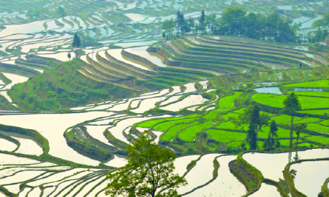
Terrace is a kind of farmland built on a hill, which in general is divided into four types in the Plateau, namely sloping terrace, interval terrace, flat terrace and back-slope terrace (Fig. 3) (28). Terrace in the watershed of the Yellow river has a long history. There is terraces dating documented and verifiable, back to the Ming and Qing dynasty (1368~1840), and there are hundreds of thousands of terraced hectares of historical legacy. After the founding of New China, governments of all levels have paid attention to the construction of terrace over the last 60 years. Before 1958, the terrace was mainly built on the hill; after 1958, mainly constructed as level terrace, and since 1990, mechanized level terracing has been adopted and construction efficiency was greatly improved (29). The statistics of 2008 showed that the area of terraced landscape on the Plateau covered325.6x104 ha, accounting for 22.33% of the total arable land area (1458.159x104 ha) in the Plateau (17), and it is expected that over the period of 2010~2030, 260.8x10⁴ ha of land will be terraced (17).
Terracing is the primary step for farming on the Plateau. Terraced slope can be altered to reduce the slope length and increase rainfall infiltration rate, enhancing soil water storage, improving the efficiency of water and nutrient use (4, 6, 30-32). From 1951 to 1995, retention of water of the Yellow River basin by terrace reached 19 billion m3, which accounting for 23.4% of the total storage capacity of soil and water conservation (81.27 billion m3) (29).
A large number of tests have shown that terraced water efficiency and soil conservation benefit could have attained 86.7% and 87.7%, respectively (Table 2). Effects of water and soil conservation by terraces have a very close relation with the precipitation. For example, when the single rainfall integrated parameters, annual rainfall and flood flow rainfall were less than 2010 mm2/min, 350 mm and 125 mm, the benefits of the soil and water conservation by the terraces could reach 100% (33-34). For example, when the rainfall synthesis parameter PI, rainfall in flood period, annual rainfall of runoff generation were less than 20.0 mm2/min, 350 mm and 125 mm, respectively, the benefits of the soil and water conservation by the terraces could reach 100% (34). However, the conservation benefits of terraces would be lower when rainfalls were larger.
Terrace level also affects the quality of soil and water conservation.
The terraces on the Plateau may be divided into three quality categories according to their soil and water conservation benefits (35). Category 1 is best quality, in which soil and water conservation benefits are 87% and 90%, respectively; Category 2 is good quality, the both benefits are 82% and 85%, respectively; Category 3 is poor quality with both the benefits of 76% and 78%, respectively (35). The construction of terraces greatly increased crop yields (Table 3) (36,37,38). Terraces not only increase conventional crop yields but also accelerate the development of cash crops, including vegetable, fruit and potato production on the Plateau, and increase per capita income (Fig. 4) (37). Due to agricultural development on terraces, the population carrying capacity of the Plateau also increased from the 148 people/km2 to 374 people/km2 (37). The construction of terraces also provides convenient conditions for the optimization of farming technology and has a profound impact on regional sustainable development.
3.2 Check dams in the Loess Plateau
A check dam is considered the most effective way to reduce soil erosion in the river (39-40).
Soil erosion in the Plateau is mainly derived from the slopes and river banks. In the loess gully region, the proportion of the total sediment deposited from the river banks is 90%, i.e. 9 times the amount deposited from the slopes (41-43).The check dam blocks the transport of sediment to the downstream area and collecting the sediment. The check dam raises the base level of slope’s bottom, reduces the soil erosion, and effectively prevents the soil of cutting. The check dam prevents the gully bank’s erosion. Check dams block the sediments efflux from slopes area to the gully area (44).
Dams have a history similar to that of the terraces, dating to the Ming Dynasty. Renowned water resource expert, Li Yizhi, who advocated the ‘Gouxu’theory to manage the Yellow River, and introduced check dams as part of a strategy to govern the River. In 1945, China invested in the first ‘government-run’ check dam (29). Since 1949, the construction of check dams has reduced the water and soil loss of the Plateau (45-46). In the last 50 years of the 20th century, more than one hundred thousand of check dams have been built in the Plateau (5). In 1983, the ‘Key conservation of soil and water in the Gullies’ project conducted a three-year experiment to develop appropriate planning, and technical specifications and regulations (Table 4) (44). Since the implementation of this ‘Key Gully Plan’ in 1986, 1,118 of check dams were established since then till 1999 on the Plateau (45). However, it is expected to take another 100 years to complete the remaining construction of approximately 130,000 check dams (5).
Dams constructed in the Yellow River region (1951~1952) held back 9.6 billion m3 of water accounting for 11.8% of the total impeded by conservation measures. The effect of intercepted sediment and reduced runoff is closely related to the height of each check dam. According to the statistics of 4,877 check dams, those with heights of 5~10, 10~15, 15~20, 20~25 and 25~30m, had sediment interception efficiencies of 13.5%, 27.9%, 38.3%, 42.0% and 48.4% respectively, and efficiencies of runoff reduction of 1.97%, 4.63%, 7.26%, 6.37% and 7.73%, respectively (33).
Check dams have become a unique characteristic of the Chinese Loess Plateau. They play an important role not only ecologically, but also in grain yield. Dams produce high fertility and soil moisture (5, 47). Grain output is typically increased the by 8~10 fold (5, 41)and even up to 16 fold (48) that of the hilly farmland. Planting around 1 ha of dam is equivalent to planting on 2~3 or 5~6ha of terraced slopes (48).
A study of the World Bank Loan Project for Yan River Watershed Management (1994 to 1996) showed that the input rates of dams, terraces, irrigated agricultural land were 3.3, 2.4 and 4.2 times that of hilly land, respectively, while their net benefits were 12.8, 5.1 and 13.2 times that of the inclined land, respectively (29).
Although the check dam has a significant role in reducing gully erosion and increasing agricultural production, it is still controversial. Four reasons are for this point. (1) Check dam construction requires a substantial investment in financial and human resources. (2) Due to insufficient funding, the construction quality of a majority of check dams is poor, so the collected sediment is unlikely to prevent flooding and may even exacerbate soil erosion. Owing to this poor quality, following a prolonged drought, in 1977 and 1978 they were subject to frequent rainstorms, and it was estimated that more than 80% of the dams were destroyed (5), leading to fulminant and serious soil erosion. (3) Following dam construction, agricultural production is facing enormous challenges. Because of poor drainage of new farmland near dams, nearly 33.3%~50% of the dams in northern Shaanxi and western Shanxi suffered from salinization, causing grain losses of 50 million kg. (4) The long-term ecological impact and role of this large-scale human check dam’s intervention in the Plateau is unclear (5). Therefore, the large-scale promotion of check dam construction needs careful consideration from engineering, technical and ecological angles for farming. In more recent times during China's economic development, the materials and techniques of check dam construction have been developed considerably and can effectively prevent storm erosion. Nevertheless, check dam construction requires a lot of human resources, and it continues to be an enormous financial burden (49).
3.3 Integrated management of small watersheds in the Loess Plateau
The integrated watershed control of soil erosion is a summary of long experience, and lessons learned.
Early comprehensive treatment of watersheds was applied in many countries during the 19th century (50-52), and proved to be a practical technology which could reduce soil erosion and enhance ecosystem resilience (53). The integrated watershed system is considered a small watershed as a unit, according to the characteristics and patterns of soil erosion, local conditions, farmland fortification, engineering measures taken, plant measures combined with agricultural technical measures, comprehensive management of landscape, farmland, forest and roads, rational use of rainwater and land resources, optimizing structure of agriculture, forestry and animal husbandry (23).
There are more than one million small watersheds in Yellow River Region, and each watershed is from a whole geographical unit, where the generation of sediment transport from a small basin. There is a need to consider all of the major factors controlling soil erosion for ‘integrated watersheds’. These include farmland construction, commercial forestry, fuel, protection of woodland planting, soil conservation, adjustment of agricultural structure and needs of local people (23). It combine reduction of soil erosion with local economic growth, applying a variety of effective ecological engineerings (terracing, check dams and soil reservoirs) and environmental management techniques (contour farming and straw mulch) (5). These measures started in the 1980s, coordinated the ecological restoration and increase of productivity (54). By 2000, these projects have been carried out in more than 5 000 basins (5). The CAS Institute of Soil and Water Conservation and other relevant organizations in Shaanxi Province have built 5 models, and 11 comprehensive management demonstration areas, achieving good economic and social benefits. The total loss of soil in 11 typical watersheds reduced by 50%~90%, and crop yields increased significantly.
Nevertheless, the implementation of integrated small watersheds in the Plateau presents problems. First, this project will require substantial external financial, material and human resources (5). Second, there are more than a million small watersheds in the Plateau that has been costly. Thus, although small watershed management in the area has gained remarkable success, it has been too slow to relieve environmental deterioration. Thus, at present the ecological status of the Loess Plateau is still deteriorating overall, despite some ‘partial improvements’ (55).
3.4 Grain for Green project
Grain for Green project is a large ecological engineering aiming at ecological restoration and soil erosion reduction in China (56).
According to regulations, the farmland in slope with the gradient >25° for southwest and >15° for northwest in China, respectively, should be replaced with grasses and trees. Farmers participating in the project receive grain, treeing seedlings, grasses seeds and cash as compensation provided by the government (57).
The pilot project of Grain for Green was carried out in 1999 in Sichuan, Shaanxi and Gansu provinces, and formal project began from 2002. The project involved 25 provinces and 1897 counties in China. Till now, Grain for Green project is an ecological engineering with strongest policy and became the world's largest ecological engineering (56).
Grain for Green project has changed the local employment and income structure (58). For example, in Wuqi County, the proportion of the labor force engaged in the cultivation before the ‘Grain for Green project’ was 87.82% in 1998, fell to 19.16% in 2006 (58).
The proportion engaged in animal husbandry raised from 6.3% to 24.6%, but there´s a significant decline in herd sizes, because the grazing leads to higher costs of feeding and raising forage shortages. The main labor reduced from agriculture moved to the relatively high income industries such as building construction, catering, transportation and other non-agricultural industries. After returning farmland, the compensation income becomes the main source of income of local farmers, followed by families operating income and subsidy of returning farmland to forest, the ratio were 48.31%, 27.39% and 24.30%. The grassland area increased 20.3%, the forest area increased by 13.786 times (58).
The main three factors guarantee the successful implementation of Grain for Green Project are. The first one is government's high-handed policy, there’s a huge investment for this project. The second is the rapid development of China's economy and urbanization; this provides an opportunity for farmers who migrate to cities, they can get a higher income than farming at home, the land is no longer their main income source. The third is great progress of dryland agriculture technology; it provide a guarantee to achieve enough food and higher economic benefit in limited lands (59). According to the project plan, the government subsidies of Grain for Green project will end in 2018 (60). Thus, although the sustainability of Grain for Green Project remains to be seen, but on the whole, it ought to help keeping the vegetation coverage, rural industrial structure adjustment, in order to promote the ecosystem reconstruction and sustainable development (60).
4 The development of dryland agriculture in the Loess Plateau
4.1 The significance of dryland agriculture
Dryland Agriculture is the main system, charged with the task of self-sufficiency in the Plateau (42, 61).
Since China's central government implemented the grain-for-green project in the plateau in 1999, the cultivated land area declined by 10.1% from 1996 to 2007, including a dramatic decline of 15.15% from 1996 to 2003 (62). From 2003 to 2007, the cultivated area increased by 5.95% compared with that in 2003. Between 1996 and 2007 grain productivity decreased by 3.76%, a lesser decline than that of the cultivated area (62). A dramatic decrease of total grain production in Loess Plateau was about 8.73% from 1996 to 2003, whereas between 2003 and 2007, grain production increased by 5.45% over that in 2003, owing to an increase in the area cultivated (62). In Gansu province, following the Grain-for–Green project, total grain yield, the grain yield per unit area and the grain yield per capita all increased fairly uniformly (Fig. 5). The improvement of dryland tillage techniques increased output per unit area (63-69).
Despite China’s grain production policy, it was planned to restore the ecology of western China while the price of grain fell (70). However, any change in grain production through implementation the policy should include local self-sufficiency (62), as the people of the Plateau were very poor (42). The Grain-for-Green project provides Government subsidies as a main income source for each farm household but only until 2018. An investigation of livelihoods indicates that 37.2% of farmers may re-cultivate the ‘returning land’ in the Plateau (8). Therefore, improvement of dryland agricultural techniques relates to both regional and China’s food safety, to the livelihood of local people, to the past achievement of Grain-for-Green Project and to the ecological restoration of the Loess Plateau.
4.2 The development of dryland agricultural techniques in the Loess Plateau
The key to dryland agriculture is utilizing limited rainfall efficiently (71).
In a typical semi-arid region of the Plateau, the precipitation over farmland distributes as follows: evaporation loses 50%~60% of rainfall; plant transpiration used 30%~40% rainfall; and about 10% rainfall lost as runoff or by other routes (72). The annual precipitation over the entire Plateau is about 3000 billion m3, which is equivalent to five times the amount needed in this area (72). Water-harvesting eco-agriculture is the main tillage mode to increase the efficiency of use of precipitation in the semiarid Loess plateau (73).
A series of tillage techniques are designed for rainfall harvesting at minimal cost. These techniques are successful examples for improving grain productivity in dryland of developing countries (74). The system is based on traditional terraces and horizontal trenches to gather precipitation. Either the rainwater is gathered into a underground cistern to supplement irrigation at the critical period of crop growth, or the rainwater is drained into the crop planting zone by the rainwater harvesting surface, e.g. a plastic film mulched ridge-furrow system, which can enhance the water supply in plant growth zone (75-77). The technique can improve rainfall utilization efficiency in dryland.
4.2.1 Limited (supplementary) irrigation technique of the dryland Loess Plateau
Supplementary irrigation was mainly due to the farmer’s requirement of low cost and a growing shortage of ground water resource (78).
Limited irrigation achieved good results in the Midwest Great Plains in the U.S., where the rainfall is about 480mm annually.
Experiments showed that continuous cultivation of dryland is possible when limited irrigation (about 150mm) is carried out at the critical stage of a crop’s water requirement.
Grain production could be increased by over 60%, and water efficiency doubled compared with an adequate irrigation treatment (78). In China, according to the local situation, some expert defined the limited irrigation as ‘according to the amount of available water resource in local area and water requirement of local crop, the manager conduct the lowest water supplying based on the natural rainfall condition’ (72). In the hilly region of the Plateau, the irrigation water relies mainly on rainfall. Underground water tanks can be established to collect rain and provide supplementary irrigation at the critical stage of crop growth.
In Gansu province, a typical semiarid region of the plateau, a so-called ‘121’ rainwater harvesting project had been initiated by the local government in 1995. The government supported the construction by each household, one area for water collection, two storage areas and one to plant cash crops (71).
This project has successfully provided drinking water for 1.3 million people and their 1.18 million livestock. In 1997~1998 a rainwater catchment and irrigation project was instituted to provide supplemental irrigation water with a highly efficient method. This produced higher crop yields (79-80) and full utilization of natural rainfall to support dryland agricultural with water-saving irrigation (from 1997 to 2010).
The system of water-harvesting has been greatly improved developed a new water-tank system with low cost specifically for the semiarid Loess Plateau (81). Meanwhile, the water-harvesting technique was used together with micro-irrigation, increasing the crop’s water use efficiency (34, 82). In addition, a simple supplemental irrigation, with low cost such as wet sowing and hole irrigation with mulching, could further improve the crop water use efficiency (71). Nevertheless, limited irrigation could not be used widely for grain crops in the semiarid Plateau, because of the small quantities of rain collected and the high cost of establishing the system (80). In order to benefit from the cost of an increase in supply of unavailable water, it is recommended that supplemental irrigation should be used mainly for cash crops, e.g. potatoes and other vegetables.
4.2.2 Ridge-furrow mulching technologies in the Loess Plateau
Ridge-furrow mulching technologies (RFMTs) were proposed and innovated by a local research worker in Gansu province (83).
In the central area of the Plateau in Gansu province, the yields of wheat, oat, potato and pea are low and unstable (the spring wheat yield is 2,250~3,000 kg per ha). In order to improve farmers’ livelihoods, RFMTS are used to extend planting of maize in the semi-arid Plateau. These RFWHS are based on the concept of gathering and using rain in-situ (Fig 7). By modifying the micro-topography of farmland, limited rainfall is retained in the furrow- the location of the crop root zone. Rain is redistributed in space at the field level (84). It is an innovative technique for boosting crop productivity in semiarid rain-fed environments (85).A field is cultivated with a wide ridge and a narrow ridge (‘double ridge’) before spring or autumn sowing, and then the entire soil surface is covered by plastic film. The seeds are sowed in the furrow between broad and narrow ridges (Fig.6).
Maize grain yield on RFMTS could reach 7 500~9 000 kg ha-1, higher than other traditional crops, e.g. wheat, oat, pea and maize without film covering (86). RFMTS increase maize yield by 30%~90% compared with normal cultivation (86), and wheat yield by 100%~150% (75). In the cooler region of northwest China, maize cannot attain reproductive development in time to produce a viable cob, but with a plastic film mulching the crop can be planted earlier and it emerges earlier so that reproduction is not compromised (67, 86-87). The increased quantity of maize straw assists local livestock breeding (88) and reduces grazing pressure on natural grassland. As a consequence of the tremendous increase in yield, the areas over which RFMTS are used has gradually increased, and they have been adopted for crops such as wheat and potato (89-91).
From 2008, use of RFMTS has been extended by the Ministry of Agriculture to Qinghai, Inner Mongolia, Ningxia, Shaanxi and Shanxi provinces.
Through long-term research and practice, the best ratio of ridge, furrow and plastic covering time has been determined for various climates, soil types and crop water requirements (84, 92-93). Increased yields with RFMTS should be attributed to three factors: (1) inhibiting water evaporation from the soil surface and increasing soil water content during critical stages of crop growth by the plastic film mulching (67,83,85); (2) increasing soil temperature, and hence accelerating seedling emergence and early growth in cooler locations (85, 94) and (3) improving soil nutrient availability, especially nitrogen (81). RFMTS contribute to rain use and crop yield where the annual precipitation is in the range of 230~440 mm (95).
RFMTS increase crop yield but with excessive soil utilization (96). As a result of increased soil temperature and moisture content, soil microbial C and N biomass, soil enzyme activity, soil respiration rate and nitrogen mineralization rate are all increased (92, 97-98). Thus, Li et al (99) reported that in an upland rice system soil organic matter and total N could be reduced by 8.3%~24.5% and 5.0%~22.0%, respectively, with film covering in contrast to that without the film. Therefore, it is proposed that the application of RFMTS should be combined with increasing soil organic matter content (100). The ‘white’ pollution (plastic mulching waste) has led to dispute in dryland application of RFMTS. A few studies have focused on the effect of plastic film residues on crop yield and soil quality. It is estimated that about 45kg ha-1 yr-1 of plastic film residues occur. We conducted a pilot field experiment with 10-year, 30-year and 60-year accumulative residue of plastic film in Zhonglianchuan and Xiaguanying, Yuzhong County, Gansu province. The corresponding amount of plastic film residue was 450kg ha-1, 1,350 kg ha-1 and 2,700 kg ha-1, respectively. The film was shredded and incorporated into the field. The preliminary result showed that this residue has no significant influence on maize yield in contrast with the treatment without film incorporation (Table 5, unpublished data). But further research should be conducted on the effect of film residue on crop yield and soil quality over extended periods.
5 Conclusions
The two key driving forces of ecological degradation in semi-arid areas of the world are nothing more than climate change and unsuitable human activities.
Climate change has resulted in drier and warmer in the Loess Plateau. This leads to a decline in vegetation and then to a series of environmental issues. Unsuitable human activities implies that in order to increase food production or land income for ridding the local poverty, the people have to cultivate and over-graze more land, which results in damage to sustainability of the ecosystem, and then in its further degradation. Ecological degradation enlarges the gap between demands of local people and ecosystem services. This leads to further aggravated predatory land reclamation, and a vicious cycle of ecological degradation occurs.
The primary way to overcome the ecological problems is to increase unit land productivity so that a fewer area of cultivated land meets the needs of the local population. This procedure alleviates the ecological pressure, providing the space for its ecological restoration.
The Loess Plateau Region is a unique area with an historic accumulation of loess. Excess land reclamation and
over-grazing for food production resulted in an extensive environmental degradation, causing widespread poverty that has plagued the local government and people for many decades. Since P R China was founded in 1949, the Central Government and social organizations have paid much more input to the development of the plateau, and taken a series of measures including the application of ecological engineering and improvement of agricultural techniques. However, this region was still impoverished and ecological deterioration continued before the turn of the new century.
From the year 2000, dryland farming productivity on the plateau has increased significantly and livelihood greatly improved with the farming development of new techniques of high rainfall use efficiency. Meanwhile, the progress of China’s economy has promoted a rapid urbanization and more and more local young residents move to cities to find jobs. Both movements are the main driving forces to land use change and ecological restoration. The local people can use less land than before to feed themselves and improve their living standard. A greater area has been returned to grassland or natural vegetation. The area of vegetation has increased while the climate has become drier and warmer.
The change of the pattern of land use shows a new promise for the Loess Plateau, and it contributes to the strategy of “large land for ecological restoration and small land for farming production” in the Loess Plateau. However, there is still a long way to go for dryland farming development of the Plateau owing to uncertainty and future challenges of climate changes. More research and further positive measures should be taken to establish new complex ecosystems and realize the harmony of production and environment in the context of climate change.
Acknowledgement
The authors are grateful to Dr Frape David for his patient advices and to Dr Pete Falloon for his valuable commentary. This research was supported by program of Chinese Ministry of Science and Technology (2011BAD29B04), MOST International Sci-Tech Cooperation Program (2010DFA32790), ‘111’ Project (B0751), and the Fundamental Research Funds for the Central Universities (lzujbky-2010-k02, 860974).
References
1. An, P., Inoue, T., Zheng, M. Q., Eneji, A. E. (2014). Agriculture on the Loess Pleateau. In: A. Tsunekawa et al. (eds), Restoration and Development of the Degraded Loess Plateau, China, Ecological Research Monographs. Springer Japan. 61-76.
2. Shi, N. H. (1988). The research on the changing of forest in history. The Historical Geography Works of China. 1:1-17.
3. Shi, N. H. (2001). Study on historical geography of Chinese Loess plateau. Zhenzhou: Yellow River Water Conservancy press.
4. Shi, H., Shao, M. (2000). Soil and water loss from the Loess Plateau in China. Journal of Arid Environment. 45: 9-20.
5. Xu, X. X., Zhang, H. W., Zhang, Ou. Y. (2004). Development of check-dam systems in gullies on the Loess Plateau, China. Environmental Science and Policy. 7: 79–86.
6. Chen, L. D., Wei, W., Fu, B. J., Lü, Y. H. (2007). Soil and water conservation on the Loess Plateau in China: review and perspective. Progress in Physical Geography. 31(4): 389-403.
7. Qin, J. M., Chen, C. (2005). The development period of Green for Grain and its policy succession in China. Journal of Agrotechnical Economics. 1: 60-63.
8. Cao, S. X., Xu, C. G., Li, C. C., Wang, X. Q. (2009). Attitudes of farmers in China’s northern Shaanxi Province towards the land-use changes required under the Grain for Green Project, and implications for the project’s success. Land Use Policy. 26: 1182–1194.
9. Li, F. M. (1999c). On agricultural productivity and ecosystem’s sustainability in semiarid areas of China. Resources Science. 21(5):25-30.
10. Xia, Z. K. (1997). Quaternary Environmentology. Beijing: Peking University Press. pp58-67.
11. Ba, D. H., Zhu, Y. J., Wang, R. S., Wang, X. H. (2005). Research summary about climate change and Chinese loess plateau evolution. Arid Meteorology. 23(3):69-73, 88.
12. Liu, D. S. (1985). Loess and environment. Beijing: Science press. 126-147.
13. Wang, Y. R., Yin, X. Z., Yuan, Z. P. (2004b). Main characteristics of climate system in Loess plateau of China. Journal of Catastrophology. 10(S0): 39-44
14. Zhang, J. Y., Dong, W. J., Fu, C. B., Wu, L. Y. (2003). The influence of vegetation cover on summer precipitation in China: a statistical analysis of NDVI and climate data. Advances in Atmospheric Sciences. 20(6): 1002-1006.
15. Wan, L., Zhang, X. P., Ma, Q., Zhang, J. J., Ma, T. Y., Sun, Y. P. (2013). Spatiotemporal characteristics of precipitation and extreme events on the Loess Plateau of China between 1957 and 2009. Hydrological Processes. DOI: 10.1002/hyp.9951
16. Wan, L. 2011. Spatial and Temporal Trend of Precipitation on the Loess Plateau during the Past 53 Years. Northwest A&F University. PhD thesis.
17. National Development and Reform Commission (NDRC). 2010. The outline of Integrated control and plan of Loess Plateau from 2010 to 2030.
18. Wang, Q. X., Fan, X. F., Qin, Z. D., Wang, M. B. (2012). Change trends of temperature and precipitation in the Loess Plateau Region of China, 1961–2010. Global and Planetary Change. (92-93): 138-147.
19. National Development and Reform Commission (NDRC). 2007. The national plan to response climate change in China.
20. Li, X., Zhou, J., Dodson, J. (2003b). The vegetation characteristics of the ‘Yuan’ area at Yaoxian on the Loess Plateau in China over the last 12000 years. Review of Palaeobotany and Palynology. 124: 1-7.
21. Meng, Q. M. (1996). Soil and water conservation in Loess plateau. Yellow press, Zhengzhou.
22. Yang, W-Z., Yu, C-Z. (1992). Regional management and evaluation of Loess Plateau. Science Press, Beijing.
23. Tsunekawa, A., Liu, G.B., Yamanaka, N., Du, S. (2013). Restoration and development of the degraded Loess Plateau, China. Springer.
24. Fu, X. L., Shao, M. A., Wei,X. R., Robertm, H. (2010). Soil organic carbon and total nitrogen as affected by vegetation types in Northern Loess Plateau of China. Geoderma. 155: 31-35.
25. Zhang, C., Liu, G. B., Xue, X., Sun, C. L. (2013). Soil organic carbon and total nitrogen storage as affected by land use in a small watershed of the Loess Plateau, China. European Journal of Soil Biology. 54: 16-24.
26. Ma, Z. L. (1990). The Basic Theory of Historical Geography. Shaanxi People’s Publishing House, Xian.
27. Sang, G-S. (2005). Vegetation variation of Loess Plateau during human history. Journal of Arid Land Resource Environment. 19(4):54–58.
28. Gao, R. L. (1996). Strength the terraced building for soil and water conservation in Yellow river basin. Soil and Water Conservation in China. (10):30-32
29. Ma, B. H., Xue, X. X., Liu, Y., Li, S. Q., Zhang, B. W. (2007). The status and function of the terrace and silt dam on Loess plateau from ecology reconstruction. Research of Soil and Water Conservation. 14(4):27-30.
30. Li, H., Wei, Y., Fang, J., Lu, X. (1994). Effects of converting hillsides to terraces in the rotten granite shale region. Soil Water Conservation China. 7: 18-21.
31. Li, X. Y. (2000). Soil and water conservation in arid and semiarid areas: the Chinese experience. Annual of Arid Zone. 39:377-393
32. Lu, H. S., Zhu, Y. H., Skaggs, T. H., Yu, Z. B. (2009). Comparison of measured and simulated water storage in dryland terraces of the Loess Plateau, China. Agricultural Water Management. 96: 299–306.
33. Jiao, J-Y. (2000). Estimation of soil loss in the area with high sand yield on the Loess Plateau—under different hydrological years and different soil and water conservation measures. Doctoral Dissertation, Northwest A&F University.
34. Wu, P. T., Wang, Y. K., Xin, X. G., Zhu, D. L. (2008). Integration and demonstration of the date micro-irrigation technology in the hilly of Shanbei. Agricultural Research in the Arid Areas. 26(4): 1-6
35. Jiao, J. Y., Wang, W. Z. (1999). Effect on soil and water conservation benefit of level Terrace by it’s quality on the Loess plateau. Territorial Development and Management. 9(4): 52-56.
36. Yong, X. U., Yang, B., Tang, Q., Liu, G. B., Liu, P. L. (2011). Analysis of comprehensive benefits of transforming slope farmland to terraces on the Loess plateau: A case study of the Yangou watershed in Northern Shaanxi Province, China. Journal of Mountain Science. 8: 448-457.
37. Liu, X. H., He, B. L., Li, Z. X., Zhang, J. L., Wang, L., Wang, Z. (2011). Influence of land terracing on agricultural and ecological environment in the loess plateau regions of China. Environmental Earth Sciences. 62(4): 797-807.
38. Shan, L. (1981). The pathway of enhancing productivity in area of water and soil lost in Loess plateau. Bulletin of Soil and Water Conservation. 1:33-41
39. Xin, Q. C., Liu, L., Shi, W. B. (2004). The design for the optimum height of warping dam. Research of Soil and Water Conservation. 11: 154–56.
40. Valentin, C., Poesen, J., Li, Y. (2005). Gully erosion: impacts, factors and control. Catena. 63: 132–53.
41. Fang, R. (1999). Outlook of the check-dam system agriculture in Shanxi province. Soil and Water Conservation in China. 169: 4–7.
42. Li, F. M., Xu, J. Z., Sun, G. J. (2003a). Restoration of degraded ecosystems and development of water-harvesting ecological agriculture in the semi-arid Loess Plateau of China. Acta Ecologica Sinica. 23(9): 1901-1909.
43. Zhu, X. M. (2006). Rebuilding soil reservoir is a rational approach for soil and water conservation on the Loess Plateau. Science and Technology Society. 21: 320–24.
44. Huang, Z. (2000). Practice and assumption for construction of the dam system eco-engineering for gullies in Loess Plateau. Soil Water Conservation China. 22: 1–4.
45. Feng, G. (2000). The key to bring the Yellow River under control is to speed up construction of check-dams in the Sandy and Grit Areas. Science and Technology Review. 145: 53–57.
46. Wei, W., Chen, L. D., Fu, B. J., Zhao, X. F., Huang, Z. L., Gong, J. (2006). Soil and water loss affected by land use under different rainfall patterns in the semiarid loess hilly area. Bulletin of Soil and Water Conservation. 26(6): 1-5.
47. Li, Z. (1995). Construction and outlook analysis for check-dams in the Loess Plateau. Journal of Soil and Water Conservation. 4: 44.
48. Liu, X. Z., Zhao, X., Su, Q. (2006b). Ecological Restoration and its Effects on Grain Production in the Corrosive Region of Loess Plateau. China Population, Resources and Environment. 16(2): 99-104.
49. Huang, Z. Q. (2002). The strategy of soil and water conservation in Loess plateau. Journal of Soil and Water Conservation. 16(5):82-85
50. Nelson, L. S., Weschler, L. F. (1998). Institutional readiness for integrated watershed management: the case of the Maumee river. The Social Science Journal. 35: 565–76.
51. Bellamy, J. A., McDonald, G. T., Syme, G. T. (1998). Evaluating integrated resource management. Society and Natural Resources. 12: 337–53.
52. Rao, K. H. V., Kumar, D. S. (2004). Spatial decision support system for watershed management. Water Resources Management. 18: 407–23.
53. Mailhot, A., Rousseau, A.N., Massicotte, S., Dupont, J., Villeneuve, J. P. (1997). A watershed based system for the integrated management of surface water quality: the GIBSI system. Water Science and Technology. 36: 381–87.
54. Liu, Z. (2005). Small watersheds integrated management for soil and water conservation in China: review and prospective. China Water Resources. 22: 17–20.
55. Li, S. Q. (2003). Study on regional ecological restoration and sustainable development of Loess Plateau. Doctoral dissertation of Shanxi University. Taiyuan.
56. Liu, C. H., Luo, Y. Q., Lian, Z. M., Chen, Z. L. (2006a). Sustainable development of ecological agriculture in northern Shaanxi Loess Plateau.
Journal of Anhui Agricultural Sciences. 34: 4463–4464.
57. Liu, Z., Li, B. G. (2012). Spatial and temporal changes in grain production before and after implementation of Grain for Green project in Loess Plateau region. Transactions of the Chinese Society of Agricultural Engineering. 28(11): 1-8.
58. Li, F. M., Wang, J., Zhao, S. L. (1999b). The rainwater harvesting technology approach for dryland agriculture in semiarid Loess Plateau of China. Acta Ecologica Sinica. 19(2): 259-264.
59. Tian, Y., Su, D. R., Li, F. M., Li, X. L. (2003). Effect of rainwater harvesting with ridge and furrow on yield of potato in semiarid areas. Field Crops Research. 84(3): 385 – 391.
60. Li, F. M., Wang, J., Li, S. Q., Song, Q. H., Xu, H. L. (2004a). Productivity and soil responses to plastic film mulching duration on spring wheat cropland in semiarid area. Soil & Tillage Research. 78 (1): 9-20.
61. Liu, C. A., Zhou, L. M., Li, F. M., Jin, S. L. (2009). Effects of plastic film mulch and tillage on maize productivity and soil parameters. European Journal of Agronomy. 31(4): 241-249.
62. Zhou, L. M., Li, F. M., Jin, S. L., Song, Y. J. (2009). How double ridges and furrows mulched with plastic film affect soil water, soil temperature and yield of maize on the semiarid Loess Plateau of China. Field Crops Research. 113(1): 41-47.
63. Zhao, H., Xiong, Y. C., Li, F. M., Wang, R. Y., Qiang, S. C., Yao, T. F., Mo, F. (2012). Plastic film mulch for half growing- season maximized WUE and yield of potato via moisture- temperature improvement in a semi-arid agroecosystem. Agricultural Water Management. 104(1): 68-78.
64. Zhou, D. C., Zhao, S. Q., Zhu, C. (2012a).The Grain for Green Project induced land cover change in the Loess Plateau: A case study with Ansai County, Shanxi Province, China. Ecological Indicators. 23: 88-94.
65. He, M. J., Zheng, S. F., Li, H. (2008). Analysis on rural economic restructuring after rehabilitating plough to forest (grassland)-based on Wuqi County in Shaanxi province. Journal of Northwest A & F University (Social Science Edition). 8(4):21-26.
66. Li, L. (2007a). Economic post-evaluation of "1-2-1" Rainwater Harvesting Project in Gansu Province. China Rural Water and Hydropower. 9:50-52.
67. Shan, L. (2002). Development Trend of Dryland Farming Technologies. Scientia Agricultura Sinica. 35(7): 848-855.
68. Li, F. M., Xu, J. Z. (2002). Rainwater-collecting eco-agriculture in semi-arid region of Loess Plateau. Chinese Journal of Eco-Agriculture. 10(1):101-103.
69. Gosar, B., Baricevic, D. (2011). Incorporation of a ridge-furrow-ridge rainwater harvesting system with mulches in high-value plant production. Irrigation and Drainage. 60: 518-525.
70. Li, F. M., Guo, A. H., Wei, H. (1999a). Effects of Plastic Film Mulch on the Yield of Spring Wheat. Field Crops Research. 63(1): 79-86.
71. Zhang, Y. F., Wang, Y. F., Liu, L. X., Hou, X. Y. (2002). Research progress on arid-land agriculture in northern China. Geographical Research. 21(3): 305-312.
72. Zhao, X. N., Wu, P. T., Feng, H., Wang, Y. K. (2009). Advance in research of supplemental irrigation of collected rain water for eco-agriculture in semi-arid Loess Plateau of China. Scientia Agricultura Sinica. 42(9): 3187-3194.
73. Steward, B. A. (1983). Yield and water use efficiency of grain sorghum in a limited irrigation-dryland system. Agronomy Journal. 75: 629- 634.
74. Zhu, Q., Li, Y. H. (1998). On rainwater catchment and utilization. Proceedings of the International Symposium and 2nd National Conference on Rainwater Utilization. Xuzhou, China.
75. Li, F. M., Zhao, S. L., Duan, S. S., Gao, S. M., Feng, B. (1995). Preliminary study on limited irrigation for spring wheat field in semi-arid region of loess plateau. Chinese Journal of Applied Ecology. 6(3): 259-264.
76. Wang, G. Z., Gao, J-En., Xiao, K. B., Fan, H. H., Yang, S. W., (2008). Monitoring analysis on water quality change of a new kind of rubber-plastic cellar. Agricultural Research in the Arid Areas. 26(2): 150-153.
77. Hou, X. Y., Wang, F. X., Han, J. J., Kang, S. Z., Feng, S. Y. (2010). Duration of plastic mulch for potato growth under drip irrigation in an arid region of Northwest China. Agricultural and Forest Meteorology. 150: 115-121.
78. Zhao, H., Wang, R-Y., Ma, B-L., Xiong, Y-C., Qiang, S-C., Wang, C-L., Liu, C-A., Li, F-M. (2014). Ridge-furrow with full plastic film mulching improves water use efficiency and tuber yields of potato in a semiarid rainfed ecosystem. Field Crops Research. 161: 137–14879. Li, S. Q., Li, F. M., Song, Q. H., Wang, J. (2001). Effects of plastic film mulching periods on the soil nitrogen availability in semiarid areas. Acta Ecologica Sinica. 21(9): 1521-1526.
80. Gan, Y. T., Kadambot H. M., Siddique, Turner, N. C., Li, X. G., Niu, J. Y., Yang, C., Liu, L. P., Chai, Q. (2013). Ridge-Furrow Mulching Systems—An Innovative Technique for Boosting Crop Productivity in Semiarid Rain-Fed Environments. Advances in Agronomy. 118: 429–476.
81. Hai, L. (2010). Effects of plastic-film mulching on maize yields and soil quality in the semi-arid Loess Plateau of China. PhD thesis, Lanzhou University.
82. Jin, S. L., Zhou, L. M., Li, F. M., Zhang, G. Q. (2010). Effect of double ridges mulched with wide plastic film on soil water, soil temperature and yield of corn in semiarid Loess plateau of China. Agricultural Research in the Arid Areas. 28(2): 28-33.
83. Zhang, W. S., Li, F. M., Xiong, Y. C., Xia, Q. (2012). Econometric analysis of the determinants of adoption of raising sheep in folds by farmers in the semiarid Loess Plateau of China. Ecological Economics. 74:145-152.
84. Wang, Q., Zhang, E. H., Li, F. M. (2004a). Runoff efficiency and soil water comparison of plastic-covered ridge and ridge with compacted soil at different rainfall harvesting stages in semiarid area. Acta Eologica Sinica. 24(8): 1816-1819.
85. Wang, X-L., Li, F-M., Jia, Y., Shi, W-Q. (2005c). Increasing potato yields with additional water and increased soil temperature. Agricultural Water Management. 78(3): 181- 194
86. Tian, Y., Li, F. M., Liu, X. L. (2007). Effect of different ridge-furrow planting patterns of potato on soil evaporation in semiarid area. Chinese Journal of Applied Ecology. 18(4): 795-800.
87. Song, Q. H., Li, F. M., Liu, H. S., Wang, J., Li, S. Q. (2003). Effect of plastic film mulching on soil microbial biomass in spring wheat field in semi-arid loess area. Chinese Journal of Applied Ecology. 14(9): 1512-1516.
88. Wang, Q., Zhang, E. H., Li, F. M., Wang, X. L. (2005b). Optimum ratio of ridge to furrow for planting potato in micro-water harvesting system in semiarid areas. Transactions of the CSAE. 21(1): 38-41.
89. Wang, Q., Zhang, E. H., Li, F. M., Li, F. R., Xu, C. L. (2005a). Effect of generation characters of mini-size water collection by ride sand furrows in semiarid area of Loess plateau and related potato planting techniques. Chinese Journal of Ecology. 24(11): 1283-1286.
90. Ren, X., Chen, X., Jia, Z. (2009). Ridge and furrow method of rainfall concentration for fertilizer use efficiency in farmland under semiarid conditions. Applied Engineering in Agriculture. 25: 905–913.
91. Wang, J., Li, F. M., Jia, Y., Li, S. Q., Song, Q. H. (2004c). Effects of plastic film mulching and pre-sowing irrigation on yield formation of spring wheat. Journal of Desert Research. 24(1): 77-82.
92. Li, F-M., Song, Q-H., Hao, J-H., Jjemba, P. K., Shi, Y-C. (2004b). Dynamics of soil microbial biomass C and soil fertility in cropland mulched with plastic film in a semiarid agro-ecosystem. Soil Biology and Biochemistry. 36(11): 1893-1902.
93. Bu, Y-S., Miao, G-Y., Zhou, N-J., Shao, H-L., Wang, J-C. (2006). Analysis and comparison of the effects of plastic film mulching and straw mulching on soil fertility. Scientia Agricultura Sinica. 39(5): 1069-1075.
94. Li, X., Shi, H. B., Chen, M. J. (2007). Effects of the supplemental irrigation of harvested rainwater on the growth and yield of maize. Transactions of the CSAE. 23(4): 34-38.
95. Zhou, L. M., Jin, S. L., Liu, C. A., Xiong, Y. C., Si, J. T., Li, X. G., Gan, Y. T., Li, F. M. (2012b). Ridge-furrow and plastic- mulching tillage enhances maize-soil interactions: opportunities and challenges in a semiarid agroecosystem. Field Crops Research. 126: 181-188.
96. 1.Wang, J., Li, F. M., Jia, Y., Li, S. Q., Song, Q. H. (2004). Effects of plastic film mulching and pre-sowing irrigation on yield formation of spring wheat. Journal of Desert Research. 24(1): 77-82.
97. Li, F-M., Song, Q-H., Hao, J-H., Jjemba, P. K., Shi, Y-C. (2004). Dynamics of soil microbial biomass C and soil fertility in cropland mulched with plastic film in a semiarid agro-ecosystem. Soil Biology and Biochemistry. 36(11): 1893-1902.
98. Bu, Y-S., Miao, G-Y., Zhou, N-J., Shao, H-L., Wang, J-C. (2006). Analysis and comparison of the effects of plastic film mulching and straw mulching on soil fertility. Scientia Agricultura Sinica. 39(5): 1069-1075.
99. Li, X., Shi, H. B., Chen, M. J. (2007). Effects of the supplemental irrigation of harvested rainwater on the growth and yield of maize. Transactions of the CSAE. 23(4): 34-38.
100. Zhou, L. M., Jin, S. L., Liu, C. A., Xiong, Y. C., Si, J. T., Li, X. G., Gan, Y. T., Li, F. M. (2012). Ridge-furrow and plastic- mulching tillage enhances maize-soil interactions: opportunities and challenges in a semiarid agroecosystem. Field Crops Research. 126: 181-188.
Figures
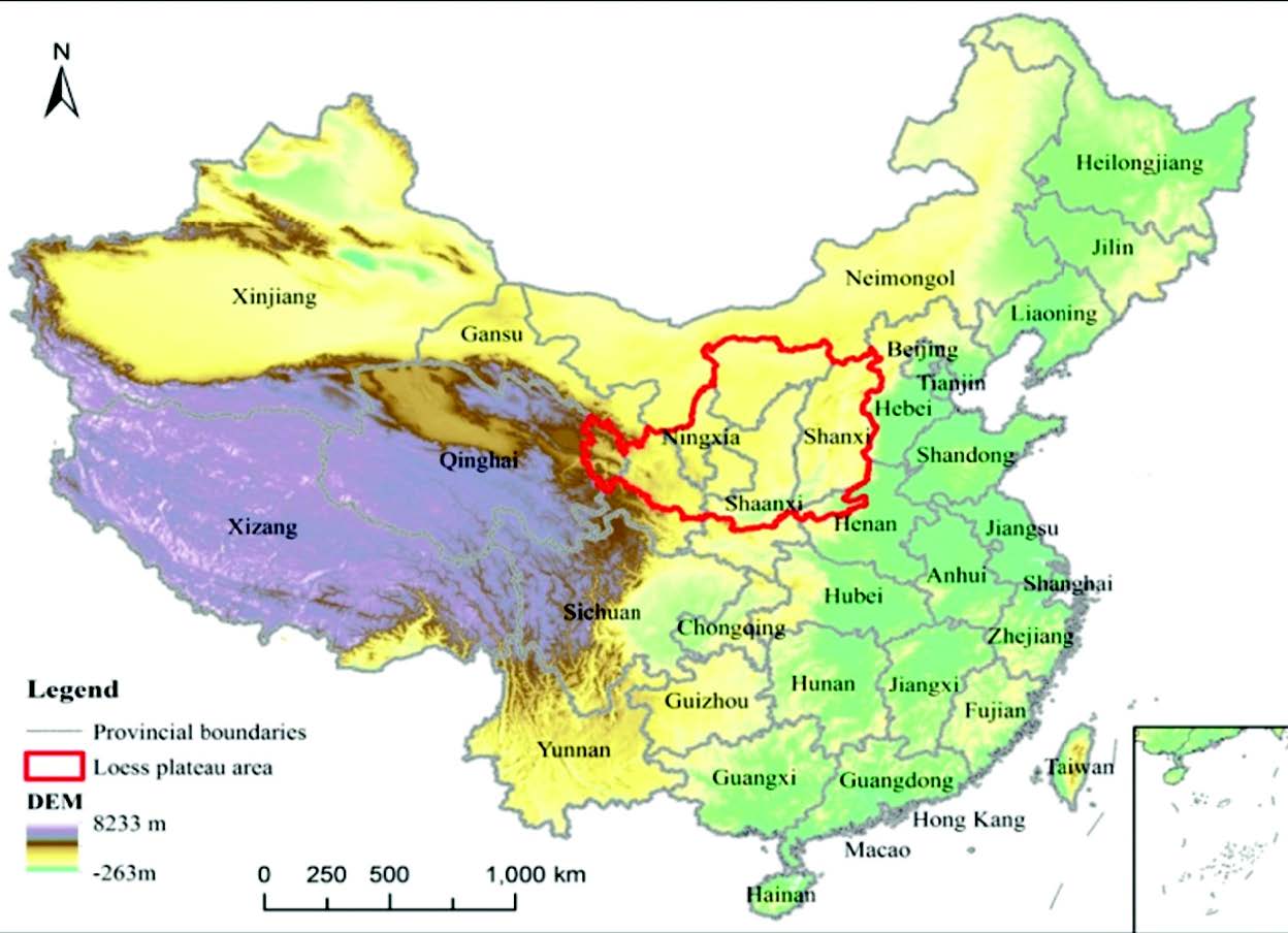
Figure 1. Maps showing location and coverage of the Loess Plateau
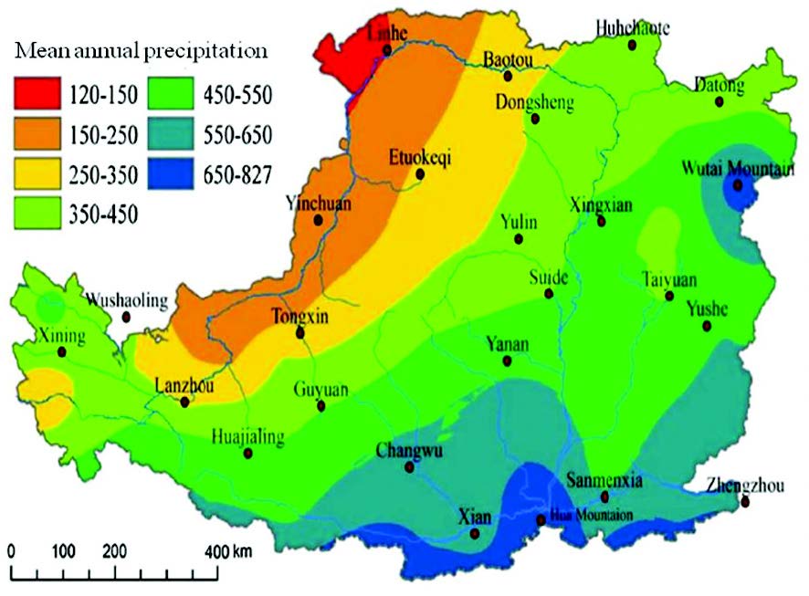
Figure 2. The distribution of mean annual isohyets from nearly 830 mm in the southeast of the Loess Plateau to nearly 100 mm in the northwest in 1957-2009 (Wan et al., 2013)
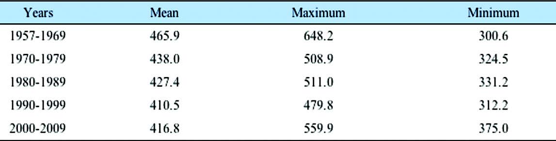
Table 1. The variations in annual precipitation (mm) in different decades across the Loess Plateau, China (Wan et al., 2013).
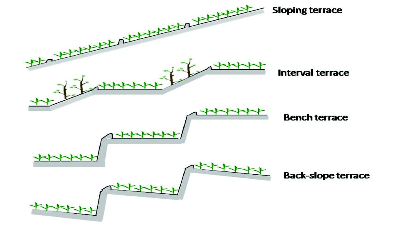
Figure 3. Diagrammatic map of four types of terrace in the Loess Plateau
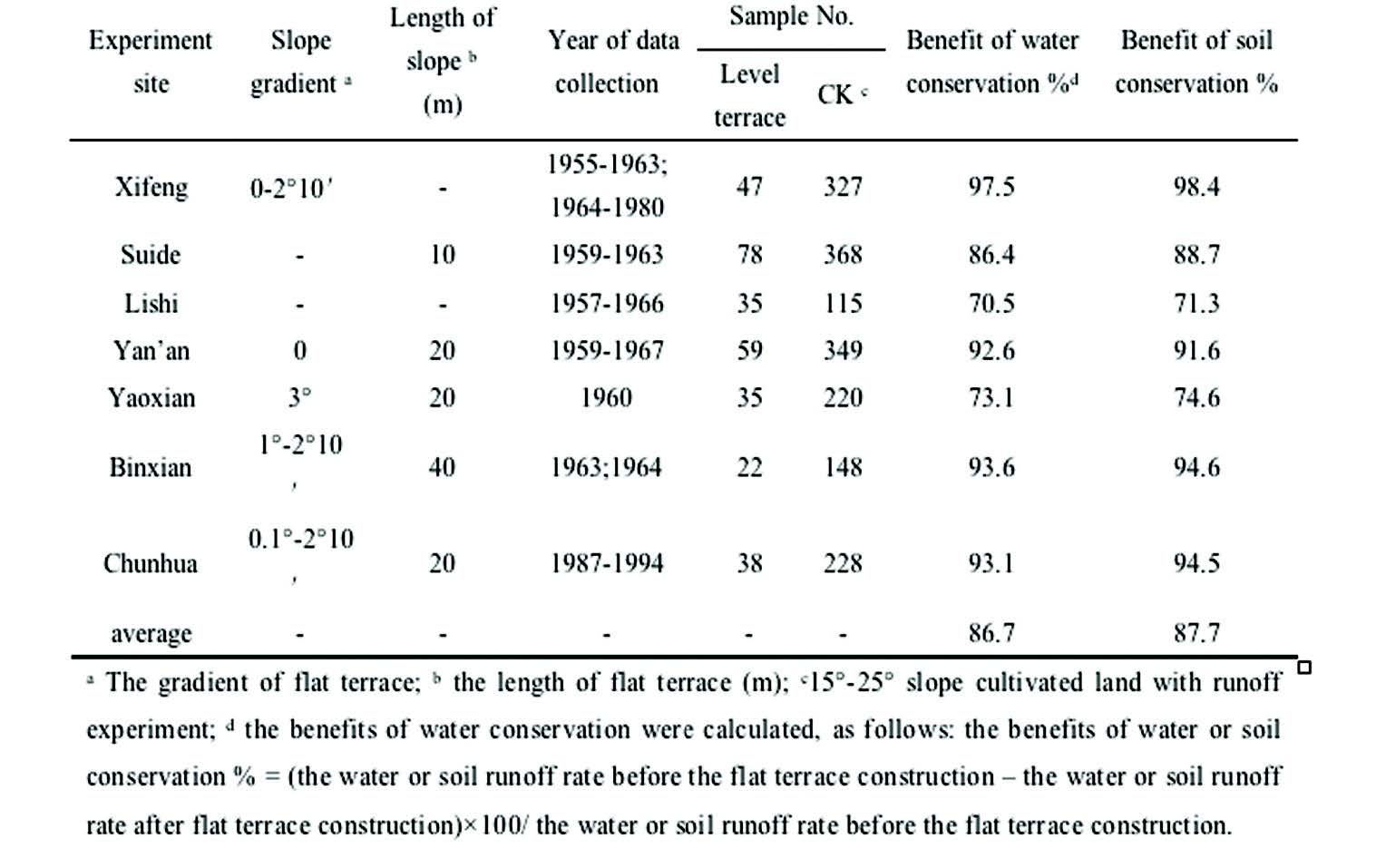
Table 2. The benefits of soil and water conservation of flat terrace on the Loess Plateau (Wu et al., 2004).
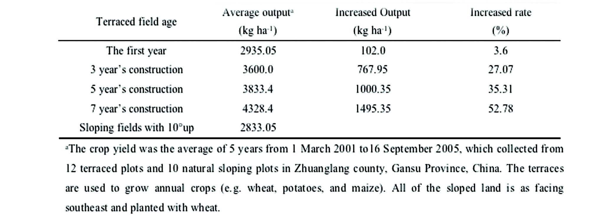
Table 3. Crop production and increases compared with yields in sloping fields >10o on terraced land constructed in different years (Liu et al., 2011).
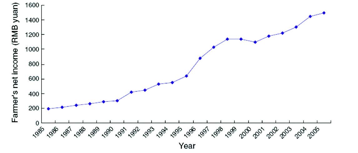
Figure 4. Farmers income per capita (Yuan) during 1985-2005 in Zhuanglang County, Gansu Province, China. (Construction of large-scale terracing across the entire Zhuanglang County started in the 1960s, and in 1998 almost the entire county was terraced. The terraced fields accounted for 95% of the total arable land) (Liu et al., 2011).
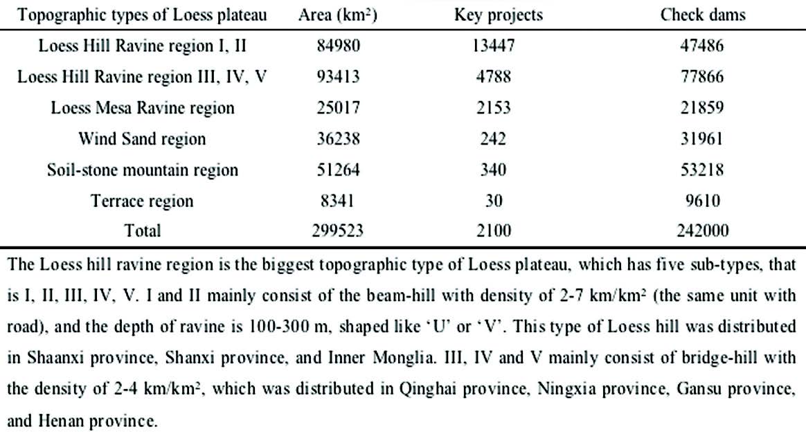
Table 4. Scheme for the check-dam systems, including numbers of key projects and check dams in the Loess Plateau (Huang, 2000)
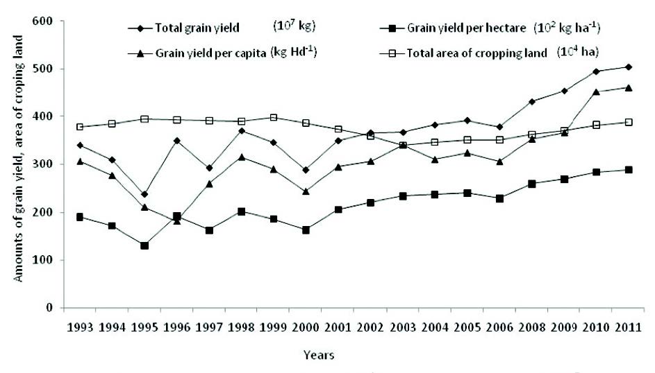
Figure 5. The dynamics of total area of cropping land (104 ha), total grain yield (107 kg), grain yield per hectare (102 kg ha-1)and grain yield per capita(kg Hd-1) in the dryland area of Gansu Province (from 1993 to 2011, which included the Yuzhong County, Huining County, Tianshui region, Pingliang region, Qingyang region and Dingxi region) (the data are from Gansu statistical yearbook).
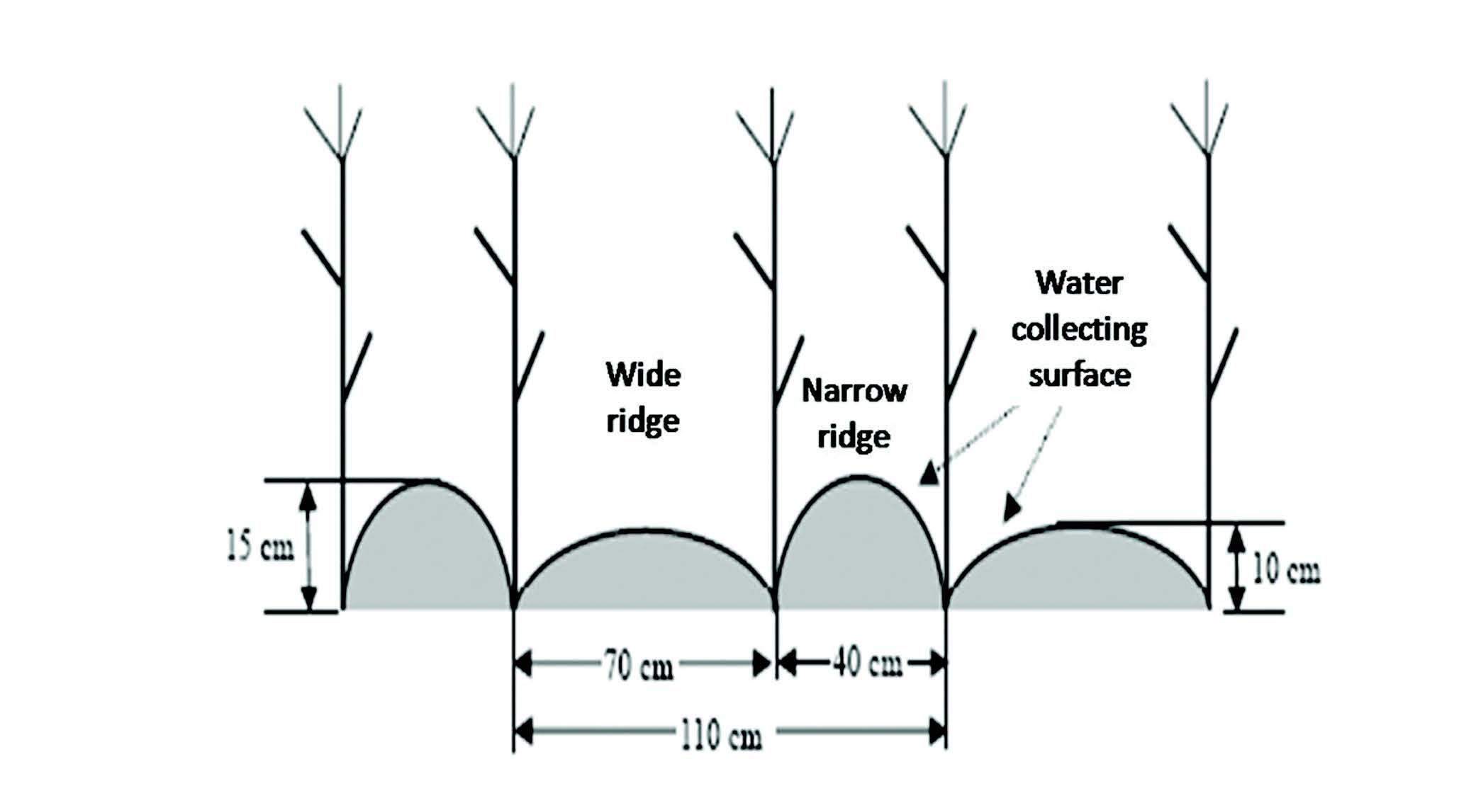
Figure 6. Sectional view in ridge–furrow rainwater-harvesting system (RFRRH).
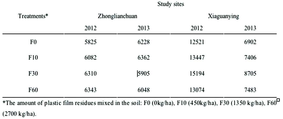
Table 5. The effect of plastic film residue into soil on maize production (kg/ha) (unpublished data from Li’s group of Lanzhou University), modeling after 0 to 60 years by F0, F10, F30, F60, measured during two years (2012, 2013)